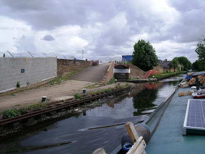
All along the cut in this area are the remains of many canal arms that served industry ranging from margarine to bricks and chemicals to gravel.
The map below is from The Grand Junction Canal by Alan Faulkner. Bulls Bridge dock--now full of houseboats--can be seen at the bottom. Our journey to Brentford is to the right.
Below is something quite unusual in that the canal passes in a cast iron trough over the railway at the same time as it passes below a road. Known locally as 'three bridges' which I think refers to the three modes of transport. The road bridges the canal, that then bridges the railway, two bridges.
Anyway it was constructed by Isambard Kingdom Brunel in 1856 and the reason was a rich landowner didn`t want the trains going through Osterly Park. There were at one time two tracks in use.
Here is the Google maps image.
Nb Valerie sandwiched between road and rail.
Above is the Hanwell Lunatic Asylum pictured in 1926.( courtesy of National Waterways Museum). The towpath bridge can be seen spanning the entrance where boats delivered coal for the boilers and brought out produce grown on the grounds by patients. Built in 1831, very little remains of--lets call it a hospital; Lunatic Ayslum is not a way to describe what might have been a lifetime home for people just like ourselves in many ways.
The towpath bridge has gone and the entrance into the hospital is bricked up. To see a map of the grounds including the dock use this link. It can be enlarged.
There is still a mental health unit here and also a major NHS general hospital. Some excellent time line info HERE. From a farm to a brewery, a cemetery to a bakery this hospital was very much self sufficient.


No comments:
Post a Comment